The mouth of Eckernförde is a pretty good place to observe the main transit belt between the North Sea and the Baltic.
This monitoring station disappeared toward the end, or shortly after, a major Russian naval exercise involving almost all of their northern fleet.
The US has moved an aircraft carrier, the Harry S Truman, near the coast of Norway, perhaps to observe Russian activity.
The Russians have two diesel-electric boats, both Kilo class, in the Baltic. Apparently, one of them has been out of commission for a while. The rumour is that they're significantly upgrading their Baltic submarine fleet.
While no passive sonar function has been disclosed for this station, it is fairly new, expensive and high-tech. It was deployed recently as an upgrade to the German data collection system in Kiel Bay.
Perhaps the Russians wished to transfer nuclear submarines to the Baltic to upgrade their fleet, and this station was seen as a concern.
This might sound like a flippant question, but I'm genuinely curious: how do you know all this? Are you a keen fan of modern naval warfare and keep abreast of it all, or do you work in the industry somehow?
There is a lot of OSINT on the web and social media. People love taking pictures of every warship that crosses the Bosporus. People read Notice To Airmen reports and share out unusual reports linked to military activity. If you follow the right people on Twitter, you can watch them analyze North Korean missile tests and identify spy satellites in almost real time.
I'm guessing a keen reader of Jane's could know this. Pretty cool intel anyway. I'd love a news media that helped summarize a lot of stuff like this, but alas you have to rely on various blogs. "News" seems more disinfo these days than anything else.
>Perhaps the Russians wished to transfer nuclear submarines to the Baltic to upgrade their fleet
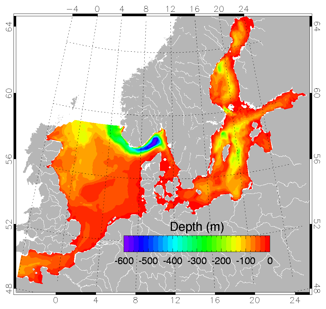
while I generally agree with you and wouldn't put anything past my old country, even outright intentional stealing of the station,I don't think it is nuclear submarine here. It is too big of a fish to operate efficiently in the Baltic "tadpool"(http://ocean.dmi.dk/models/figs/bshcmod.png), and it doesn't provide any meaningful capabilities for that battle theater. From the USSR times Russia has the Baltic covered with more than enough antiship/antisubmarine/cruise missiles and other weaponry (like the short range ballistic missiles plus medium range cruise missiles which violated that treaty) which are based on land, on aircraft and on small ships, frigates and destroyers there. Nuclear submarine really doesn't add anything here. Despite all that hardware, Russia has been beefing ups its capabilities there - a lot of the ships were made operational (they hadn't been really despite their official "operational" status) plus the above mentioned new deployments of the ballistic and mid-range cruise missiles plus new generation of antiship and antisubmarine missiles (on smaller faster cheaper ships), and also i think the smaller submarine drones. These drones are much more probably at the issue here than a nuclear sub. There is also other submarine drone type - the nuclear powered and armed "doomsday" drone https://en.wikipedia.org/wiki/Status-6_Oceanic_Multipurpose_... . It is most probably built in St Petersburg and transferred to the North and Pacific fleets. While such transfers are usually with cold reactor and without warhead, there still may be some intelligence related drama around it.
>The rumour is that they're significantly upgrading their Baltic submarine fleet.
Russian rumors and threats of upgrades and military spending are a time honored tradition, with the exception of some specific projects that are not modernization at scale... the threats and rumors usually come to nothing.
I agree that it sounds like a military op, but why assume it was the Russians? This was a civilian station. If it had any sort of listening/detection capabilities those would be a threat to all military operations, irrespective of national origin. The americans, the brits, the germans, the russians, any one of them could have taken issue with this rig.
But I think it far more likely that this was a military accident. Someone dragged an anchor, net or towed sonar array over this thing. They might not have appreciated what had happened until days/weeks afterwards.
Someone dragged an anchor or a trawl net over it and isn't about to admit to it, especially once they realize they were in a prohibited zone.
Having occasionally followed rocket launches from Wallops Island, I think I have a small sense of how often keep-out rules are violated. Unless this area had 24/7 radar monitoring, I think this is the most likely explanation.
I grew up on an island in the Baltic. Cable lines to main land snapped by anchor dragging was a surprisingly common occurrence. Other marine shenanigans included drunken sailors beaching their ships because they forgot to turn around the island. And ofcause a ton of illegal fishing.
Agreed. Bottom trawling was the first thing I thought of. The machinery is probably relatively nearby, possibly with shreds of net caught in it, sitting on the bottom.
Two units connected by a cable, weighing a combined 1700 pounds, both dragged away by accident? I have a hard time imagining that. In an accident where something on the surface snags it, I can see one of the units getting pulled away and the cable snapping, but both seems unlikely, at least for an anchor. Granted, I don't know much about what a trawl net looks like in the water or how much weight it can hold.
It reads like the beginning of a script for one of those giant-aquatic-monster summer movies starting, say, Jason Statham.
Quoting from the OP: "The seabed 'observatory', worth about €300,000 (£270,000), weighed more than half a tonne. It could not have been dragged off by a storm ... Divers only found a torn power cable at the site, 22m (72ft) down and 1.8km (1.2 miles) offshore."
Essentially, all vessels over a certain tonnage are required to broadcast identification data (AIS) for safety regulation so other vessels can identify them. Many companies now exist that listen in on those public vessel broadcasts and aggregate the date. Messages are sent by the vessels constantly, and terrestrial antenna are installed by companies, or assisted by volunteer hosts to help collect the messages along coastlines. Satellite companies can aggregate as well, but are usually hindered by how often the pass over a certain area (10 minutes of visibility every 90 minutes, depending on the constellation, and the company).
All in, the larger AIS data aggregators collect about 500 million messages a day from around 150,000 vessels through terrestrial and satellite sources. Access to the full feed, with no delay, is sold for up to $500k/year, though typical deal sizes are around $75k/year. Access to online map-based products usually cost around $10k/year.
<== Used to work for one of the large AIS companies
>The system is based on the collection and processing of data transmitted via the AIS (Automatic Identification System). The AIS-Receiving stations that comprise the MarineTraffic network pick-up such data and share it with the MarineTraffic central database.
>All vessels equipped with an AIS transponder emit AIS-data which can be received by any AIS-receiving unit provided it is within range. AIS message packets are encoded in NMEA sentences (64-bit plain text). A sample is shown below:
>!AIVDM,1,1,,B,1INS<8@P001cnWFEdSmh00bT0000,0*38
>The contents of any incoming NMEA sentence can be decoded. This way, information on the following three basic sections can be deducted:
>Dynamic Information, such as the subject vessel’s position, speed, current status, course and rate of turn.
Static Information, such as the subject vessel’s name, IMO number, MMSI number, dimensions.
Voyage-specific Information, such as the subject vessel's destination, ETA and draught.
The central database constantly receives and processes large amounts of AIS-data and stores the most important part of it (together with geographic information on a multitude of ports and areas, vessels' photos and other details). Current positions and/or tracks of vessels are displayed on the MarineTraffic Live Map while Positions History, Vessel Details, Port Conditions and Statistics can be easily found using our dedicated web pages.
Coronado the main Navy base in San Diego is mostly built on top of a sand burm. If anything is under San Diego it would have to be Miramar, or Camp Pendleton.
They bay is partly prohibited to be visited because it is used by the military.
It is also believed that a lot of ammunition was disposed there after WW2, which perhaps could offer some starting points for an explanation, even if unlikely.
The military currently uses it for torpedo tests and perhaps someone is currently really starting to sweat after reading this article.
It could have been cooperated with the NATO to monitor Russian submarine activity.
That could be the explanation why it was cutoff and took away, and not just intercepted (spliced) as usual.
You would have to dive to cut the cable. Easier, if your boat is powerful enough, to pull until the cable breaks. Ignoring malicious activity, could be something as simple as an anchor got caught and they pulled the station with it?
It cost 300k, but I can't imagine there's a huge blackmarket for fencing sea-water salinity monitors and the like, so I doubt stealing it would be worth anyones trouble.
Could this research platform have been sabotaged by a US submarine? The current administration is poised against climate change science, and submarines are reportedly used in clandestine operations to splice or cut communication cables. Perhaps it was generating data that was making someone unhappy.
Edit: I'm being downvoted for making a (not unreasonable?) supposition. I honestly wanted a discussion about submarines and/or intelligence community things.
I didn't downvote you, however the problem with your reasoning is that every country has literally hundreds of devices scattered around and measuring every day data that could make someone unhappy. The current US administration (which I deeply dislike as well) would gain nothing but the great risks involved should the agents be caught with the pants down. While they could well sabotage a few stations, there are so many around that hitting all of them is plain impossible. If we accept your theory, we should also take into account Russia as well since this happened about two weeks after that nuclear incident, and having sensors measuring radiations far away from the event would make them unhappy too. I'm assuming that station has radiation sensors on board although their presence has not been reported because they're cheap and it would be stupid not to include them especially in that area. Same problem as above: let's say some Russian agents managed to destroy that station, how would they deal with the hundreds or thousands other stations doing similar measurements around without risking a lot of PR damage if caught?
To me, assuming it was intentional, it was either someone needing spare parts for his projects (kidding) or someone who didn't want measurements to be taken in that area because they are involved in illegal dumping of pollutants or similar things.
edit: knowing the exact type of sensors on board would help a lot to find the motivations in case of deliberate sabotage; eg, a magnetometer can detect anomalies in Earth's magnetic field, such as those produced by big ships or submarines passing by.
It might also have been abducted by aliens, but it's not constructive to suggest something with a 0% probability, when rounded.
It seems like submarines splicing spy equipment into undersea cables is their biggest peace time application - and it looks like every country that can do it, does it in some form or other. It just came to light that South Africa is doing that, and they can barely keep the lights on as a nation. If a basket-case like South Africa does it, probably every developed nation does it.
It's extremely unlikely the US would do something like that to an ally. In regards to 'spying' in general, usually you don't really sabotage. You just note what's being collected and control it. Because by sabotaging something you give away that you know about it, that is has value, that you're possibly actively looking for similar things, blah blah.
I would bet money that someone dragged an anchor across the line or the device, and it has since been dragged across the sea floor to an unknown location by accident.
Highly doubtful that someone dragged an anchor across a restricted area in 72 ft of water.
I'm not an expert on nautical stuff, but only the largest vessels would have anchor chains that long. Moreover, you'd have major problems getting your anchor detached from that thing. If you cut your chain (unlikely) then it would still be at the bottom of the sea. If you somehow managed to detach the sea station, it would also be laying nearby. Presumably the divers checked the nearby seabed?
Anchors dropped where not allowed is one of the top reasons international communication lines break.
That device did not look particularly heavy when compared to the weight of a chain/line required to drop anchor at that depth (normally 5:1 or 7:1 ratio).
And the amount area a diver would have to check us significant.
Well yeah on land 750kg seems heavy. In water it's not really. A 50 foot boat/ship could easily snag that and drag it off. A larger ship might not even notice until they brought the anchor up.
As far as the dog piled parent, intelligence services are known to be loony paranoid and do really dumb stuff. Not to mention research and science projects are commonly used as cover. So sometimes the loony paranoia isn't misplaced.
The current US administrations tact is "the science is wrong" or "the science is being misinterpreted". Why go to the trouble of some cloak and dagger mission when you can simply ignore it.
Highly unlikely. Those waters are too shallow for any US-Submarines (Or british) to operate in. And its one of the prime hunting grounds for german submarines, which are based in the Area. Much too risky.
Yeah seems rather risky to be operating literally in the backyard of a major German submarine base. Six Type 212 subs are based in Eckernförde, one is actually on the marine tracker linked in the comments above [0] right now. If a submarine pops up there unannounced that's a diplomatic incident at least and with a naval base nearby the risk of discovery would be rather high.
Climate deniers have managed to ignore inconvenient, extensive data for decades. I doubt they see a need to perform an act of war to prevent a trickle of additional data.
This monitoring station disappeared toward the end, or shortly after, a major Russian naval exercise involving almost all of their northern fleet.
The US has moved an aircraft carrier, the Harry S Truman, near the coast of Norway, perhaps to observe Russian activity.
The Russians have two diesel-electric boats, both Kilo class, in the Baltic. Apparently, one of them has been out of commission for a while. The rumour is that they're significantly upgrading their Baltic submarine fleet.
While no passive sonar function has been disclosed for this station, it is fairly new, expensive and high-tech. It was deployed recently as an upgrade to the German data collection system in Kiel Bay.
Perhaps the Russians wished to transfer nuclear submarines to the Baltic to upgrade their fleet, and this station was seen as a concern.