> Unfortunately for residents of Oregon’s historically cloudy coast, NOAA scientists have calculated the chances of a clear day at about 44 percent.
...
> A few hours east, however, the odds increase dramatically. Because the Cascade Range creates a significant rain shadow across central and eastern Oregon, chances are high that the view will be unobstructed.
How good are the short term forecasts for Oregon? If the day before the forecast for an area west of the Cascades calls for a clear day, is that almost always right?
My plan currently is to drive to Oregon from the Seattle area the day before, and head to one of (1) the Salem/Albany area, (2) the Madras area, or (3) somewhere around where the 84 crosses the centerline of totality, with the choice being based on the weather forecasts at the time.
In Eastern Oregon, summer weather is either clear or thunderstorms; thunderstorms develop in the afternoon, while the eclipse is in the morning. You're exceptionally likely to get a clear day East of the Cascades.
I leave in rural Eastern Oregon. The population here is expected to swell by a factor of 5-10x during the eclipse, and this is expected to overwhelm local services. If you're headed to rural Oregon -- or probably any non-metropolitan area nation-wide -- to see the eclipse, I would recommend arriving at least two days early, plan on staying up to two days afterward, bring with you all the food and gas you'll need, and try to avoid any critical illness or injury.
Speaking specifically of Madras, its East of the Cascades, so the weather should be good. There's a rumor that they're planning to make the highways one-way between Madras, Bend and Prineville to accommodate the extra traffic. I wouldn't want to travel by car in that area during the eclipse.
We reserved an RV back in October with the intent of seeing the eclipse somewhere in your neck of the woods.
We're picking it up a full 3 days ahead of time. We're going to overnight around Shasta, and arrive almost two full days before the eclipse. We will be 100% self sufficient in the RV. That's the plan at least. (:
Here are some questions: how appropriate is it for us to park in 'some random place' for a couple of days somewhere up there?
Would you recommend being more 'east' or 'west' along the line of totality?
Do you mind me peppering you with a lot of other questions? (:
Pepper away! I love my little corner of the country and love talking about it :)
There is lots and lots of publicly owned land in Eastern Oregon. "Dispersed" camping means camping somewhere that isn't a developed campground. You can do that just about anywhere on National Forrest land (without a permit), and on lots of BLM land. Check with the forrest or BLM district in the area you're camping for the specifics. That said, lots of people are planning to do dispersed camping for the eclipse, so you might have to search around a bit for a good spot thats accessible to a class C or A motorhome.
You should stay off private ranch land. The forrest service and BLM can give you maps so you know what land is public and what is private.
If you're thinking shopping-center parking lots, the shopping centers in Grant, Harney and Lake (the area I'm familiar with) are small. Its not uncommon to see one or two RVs camping in some of the larger ones, but I suspect the eclipse crowd will be large enough that store managers will need to limit the number of RVs in their lots.
In addition, lots of people are renting out their land for RV and tent campers, so you may be able to find some of that available if you're willing to pay.
Finally, I should emphasize the degree to which the eclipse crowed will overrun local services. In Harney county, whose Northen border is near the Southern line of the path of totality, there are fewer than 10,000 people who live in more than 10,000 square miles. Estimates are that as many as 50,000 people will be in Harney county for the eclipse. In the path of totality, the ratio of visitors will be even larger. You should not rely on being able to buy gas or groceries, or dump your RV tanks in a timely fashion.
Just a warning (in case you haven't been made readily aware a thousand times already)... The local agencies (I live in SW Portland area) are basically telling the residents to treat this like a huge natural disaster.
If you were coming from Shasta to the Madras area (or just central OR in general) you'd likely be going I-5 to 97 (or further north 20/22) and they can get jammed up pretty good just on a Labor Day weekend.
Do yourself a solid and make sure you get that RV stocked and fueled to the brim before you hit the road. Expect it to be worse than the fearmongers on TV say, then be pleasantly surprised when you don't have much to worry about is the angle I'd take.
> how appropriate is it for us to park in 'some random place' for a couple of days somewhere up there?
Public lands have certain areas you can disperse camp. Other than that it is usually not ok to just random camp.
These won't be ordinary times though. I'd _expect_ people will be looking the other way or be too busy to worry about running off RV's in parking lots.
We are planning on find a spot in Idaho a week and a half before hand. Hoping the weather holds out. It won't be easy to travel day of from where we picked.
I'm not super familiar with Unity, but based on the satellite photos, I think Forrest Road 6015 will be traversable with a Class C; you should be able to find a fine place to came out there. You should call up the Prairie City Ranger District too, they'll know more local specifics than anything you can find online.
It is legal to camp on any Forest Service or BLM land. Sometimes this is restricted in very popular areas and should be signed (as one might expect, a lot of California public lands are so designated). I have not camped much in western Oregon, but eastern Oregon is mostly public lands where you can camp (unless they make special rules for the eclipse). Have fun.
In 2016, Madras went so far as to hire an event planner to organize the logistics [1]. The town has a web site with pointers to camp sites, RV parking, and day parking. (Sure, you can probably just pull off onto the side of the road, stop your car, and watch the eclipse for free, but if you want/need to be near, say, a porta-potty, this info might be useful).
> Sure, you can probably just pull off onto the side of the road, stop your car, and watch the eclipse for free, [...]
They say not to do that. From the FAQ at the Madras eclipse site:
> Can we park on the side of the highways & roadways?
> No. The Eclipse is occurring at the height of fire season in an agriculturally dominant landscape. Over-heated vehicles are of major concern. Pulling your vehicle off on to an area that is not designated for parking is not only dangerous for yourself and other drivers, but can also produce a fire.
I can confirm that EMS/LE services will be very busy. I know some people in the local ham group there who are helping and it sounds like it's going to be pretty crazy.
One of the two air ambulance services that serves my area has already announced that they will cease service surrounding the eclipse in order to have more capacity near their home base.
I am truly bewildered. Was in Madras a couple of months ago, and all the talk of eclipse was, I thought then, preposterous. Now Portland businesses are making contingency plans for employees. Have friends in Charleston, SC, with 1.5 minutes of full coverage, and it's just an excuse to drink a little more, a little earlier.
Is this a social media/regional/generational thing? Do people really think they need to be on the 100% line for some reason? Do people think they won't live to see the next one in 2024?
Yes, it's an unusual event, and creepy if you're a caveman. Otherwise, this strikes me as Chamber of Commerce hype cashing in on Facebook vanity. Seriously, I don't get it.
Totality is a completely different experience from a 99% eclipse. We are uniquely situated within the solar system in that the relative distances and sizes of the moon and sun mean they're nearly identical in size to us.
With a 99% coverage event, it is still daytime. You still need glasses to look at the sun. Animals continue behaving as normal.
With a total eclipse, day turns to night. Animals alter their behavior patterns. As the totality event begins, the corona casts flickering shadows over the ground. You can look at the sun directly with your naked eye, and observe nuclear fusion directly. On average, any given location on Earth sees a total eclipse once every 375 years, which, while astonishingly common relative to other locations in the solar system, is still extremely rare for a human lifespan.
It is equally bewildering to me that someone would not care about the opportunity to witness such an event.
That is not enough though. Since the temperature drops during any eclipse the air can suddenly hold a lot less water and you have fog ruining your view. So a place with lower humidity is the second thing to consider after the cloud cover itself.
"3/4 or 1/2 the maximum day-night temperature difference" says eclipse2017.nasa.gov[0], space.com has more details on that[1]. If this drop means the air cools below its current dew point you get fog. Seen and felt it twice with partial eclipses (both of which just happened to be where I was, so no loss).
For better or for worse, I suspect that while a significant percentage of HN readership may be planning to travel to see the eclipse, a far smaller percentage (certainly not 1/3 of Seattle) of the general population is going.
Oregon Dept of Transportation (ODOT) is expecting the single largest traffic event in Oregon history. Over one million people are expected to travel to the path of totality within the state.
If, like me, you're planning on being on the Wind River Reservation for it, don't worry too much about the permit you supposedly need. The town of Pavillion is charging five bucks for parking, but that's literally the only thing I can find anywhere that mentions any cost at all. This site, which is linked to by the city of Riverton, seems pretty official, and doesn't mention permits of any sort (...guess we'll see on eclipse day!):
This is a nice idea. NASA has created copious maps too using various resources to ensure accuracy. You can traverse and explore the path too. Interactive maps seem nicer than a linked list of screenshots in my opinion.
I started a group with a long shot dream that some day total solar eclipses will be properly celebrated in the form of giant high tech festivals http://shadow.dance. But in addition to celebration, they are opportunities for somber reflection on history. Any arbitrary long path anywhere on earth will include historic sites that reveal depressingly dark human behavior but the Aug 21 path is remarkable in that it includes the most important historic sites for almost all the dark aspects of US history, including the Minidoka Internment Camp, Fort Laramie where the Sioux were falsely promised the Black Hills, The Trail of Tears and Sullivan’s Island (North America’s largest slaveport). (The most detailed map is on p 6 of the detailed technical proposal which is 3 clicks in – the 16 sites still sadden me when I look at them.) Readers here could be a big help for our project which was unable to get support for our 2017 ambitions but hopes to find fruition in the 2024 Mexico US Canada eclipse – contact information on the web pages.
I may just be a bit thick, but what's the significance of Aug 21 in this? (In plain terms, if you can.)
Just for context: I have actually observed a total Solar eclipse, and while it was pretty significant and "awesome" in confirming my (philosophical term:) belief in Science[1], it -- in no way -- implied much else.
[1] It was predicted at least 2 years in advance... which is astounding given the speed at which the earth is hurtling around its orbit, etc. I don't think they even needed much more than Newton's laws for that prediction.
Sorry I do not really understand your question. I hope I made it clear that I do not attach any supernatural significance to the fact that the Aug 21 eclipse includes "dark" history in its path. By chance it includes historical sites that most people have heard of, and it is a shame that we couldn't drum up some luminaries to talk about them and emphasize the common themes - humans are at their worst engaging in horrors that you hate to think about - when: bigotry is widely accepted, when there is assymetry of power between groups, when ruthlessness in the pursuit of profit and power is not condemned and when the actions remain out of sight and there is no investigative journalism to reveal them. If we are of good conscience and do not want to repeat our past then we must constantly be on guard against those factors.
Oh, OK, I apologize. I think it might just have been the phrasing of your original comment that confused me. I definitely think it's a good idea to drum up a bit of interest in history, historical sites, etc. I will say, however, that the look of the webpage you pointed to did induce a little bit of a "cranky" vibe just because of the look, big fonts, etc. If you control it, you might want to tone it down it a down, or if you don't... just avoid linking to it. What you just posted is much more interesting and informative than that page.
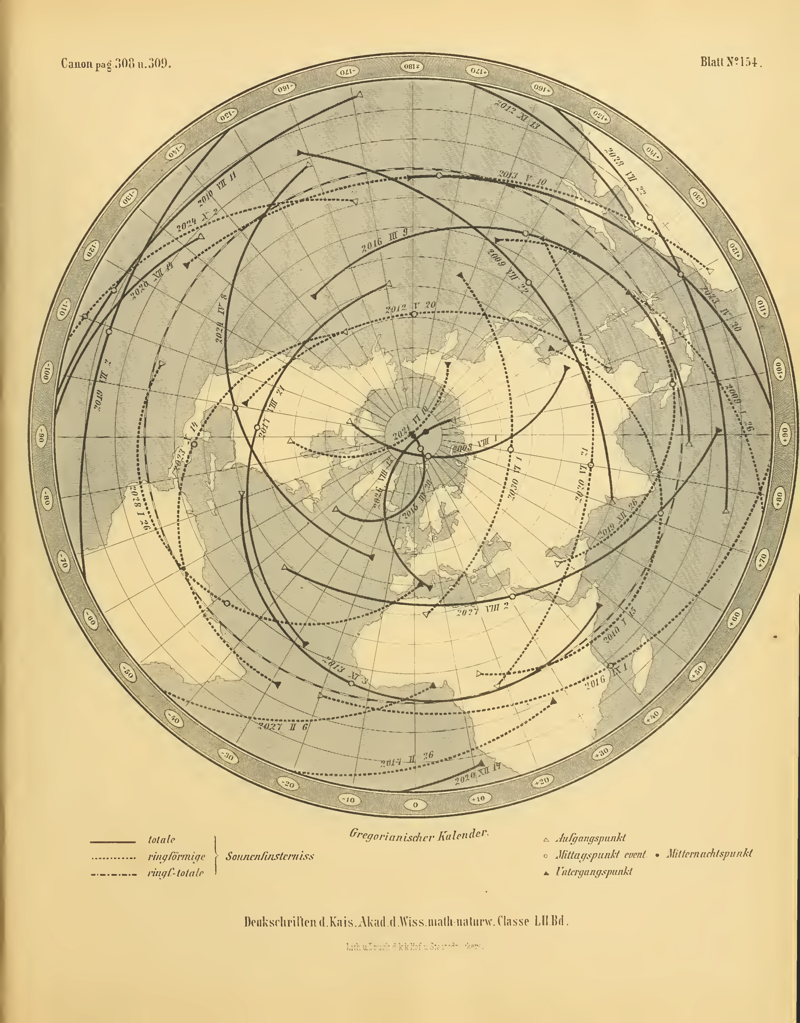
Actually, it was predicted a lot further in advance than that. The Canon der Finsternisse [1] published in 1887 shows the predicted track of the upcoming 2017 eclipse [2]. I think I read once that the author, Theodor Ritter von Oppolzer, only calculated the start, middle, and end points of each eclipse, which is why the track in [2] is a bit off.
> the Aug 21 path is remarkable in that it includes the most important historic sites for almost all the dark aspects of US history
It really isn't, and it really doesn't. It doesn't cross Dresden or Nagasaki or My Lai or Guantanamo. It crosses a lot of sites of historical political and military domestic engagements in the USA, all of which are sad for the losing side, because it crosses a large cross section of the US.
I should have said domestic history. The proposal briefly mentions inviting the creation of monuments to international suffering. See more comments below.
My summary is oversimplified but if you look at the legend on the map it indicates that the prisoners at the camp were forced to build the Minidoka Irrigation Project which crosses the shadow path from the south where the Camp was located and extends north of it. So the Camp is tied into the shadow path which in the original vision would have been noted by a monument on the path. It was surprisingly easy (by going to many different sources of course) to get GIS layers with shapefiles for everything on the map
Out of curiosity, is there a reason you've chosen to focus on "dark" events in the path? Is it because of the shadow metaphor? I'm sure there are plenty of good things that happened in the path too.
The Trail of Tears and Sullivan's island leapt out at me the very first time I saw a map of the shadow path and I have for years thought that an honest painful day of atonement around the world would be healing and humbling and a good antidote to romanticized militarism. Only Germany has come close to real atonement. Most of the rest of the world is way overdue. So I thought it would be a valuable addition to a day that bonds a nation with many of the best activities for creating harmony - dancing, cheering, working and eating together rounded out with crying together and promising never again together. Many of my thoughts are in the proposal which is way long as the event is complicated. But I have run a camp at Burning Man I have been to the Virgin of Guadalupe Festivities, and past a critical point adding events and complexity really does create an unstoppable frenzy that is more and more likely to succeed and pretty soon you can't keep people away.
The description in the article says Google Earth (not Google Maps) and that they were exported (not screenshotted). So not at all like the heavily editorialised title.
They should have mentioned which of the listed places have an airport that is served by one or more major airlines. Those places provide the opportunity of simply flying in, hanging out at the airport until the eclipse and watching from there, and then flying home.
I checked a few, looking for round trip flights from Seattle leaving Seattle the day before and returning the day of the eclipse. For some it may be possible to arrive the morning of the eclipse, but I didn't get into sufficient detail to check that.
Casper, WY: many flights, around $800. One week later is around $300, so it looks like the eclipse has driven prices up.
St. Joseph, MO: Many flights, $400-500, including a few nonstop so only 3.5 hours (as opposed to 6 to 7 for all the ones with a stop). (I did check same day for this one. There are leaving very early Monday morning from Seattle arriving before the eclipse).
Carbondale, IL: many flights, $700ish and up.
Metropolis, IL: Many, $1000ish.
Nashville, TN: Many, $500ish.
Clemson, SC: Many, $600-2000.
That was just cities that the article highlighted. There are also many fairly significant cities, some near the center of totality, that they left out. Columbia, SC (which has many flights staring at $700), for example.
St. Louis is a good hub near the eclipse track. You can rent a cheap car and head right into the New Madrid Seismic Zone to watch the eclipse from scenic Chester, IL!
Will you be able to rent a cheap car, though? I'd expect that rental cars are going to be like hotels--greatly jacked up in price on rental periods that include the eclipse, if any are even still available.
If you're actually interested in doing this from Seattle, it looks like Alaska has nonstop flights from Seattle to Charleston, SC and Kansas City. Greenville-Spartanburg, SC (GSP) is another candidate although a bit harder to get to.
Though it can be thought of as varying with latitude in this case, it's much more complicated than that for eclipses in general. So latitude can work as a pragmatic proxy variable in this case but not for all eclipses: e.g. http://www.hk-mcc.net/david/eclipse/image/se20080207.GIF
Moon's orbit is not on the equator (closer to the ecliptic), the Sun isn't fixed in the sky, etc.
So in your opinion does the linked article (it feels wrong to call it that...) accurately depict this (or at least depict it accurately enough that it's not deceiving)? Or like you kind of hinted at, is it close enough during this particular eclipse to not really matter?
it's really the shape of the projection of the shadow of the moon onto the irregular surface and doesn't really have to do with distance to the equator.
This is a nice opportunity for navigation software to set themselves apart: let the navigation along the given path be time-constrained. Thus, if the user is lagging behind, send them to a highway; if the user is ahead schedule, let them wait for a while.
Cars, and even planes are way too slow to track the moon's shadow across earth. The speed seems to vary from ~1500-3000 mph depending on how close you are to the equator. An SR-71 Blackbird would have a hard time keeping up with that.
It is also peppered with nice little sound bites of cool info:
McCool Junction, Neb., won’t get McCold, but the air temperature during totality drops by an average of about 12 degrees Fahrenheit, according to astrophysicist Fred Espenak.
As somebody planning on watching it from the Willamette Valley in Oregon, I should point out that the clouds in question will probably stick to the immediate coast. It'll be the sunny dry season past the first range of mountains.
Just booked my hotel near Carbondale to go with my family. Prices in the area are INSANE! I am genuinely excited and can't wait to see it. I hope weather will be nice.
Look forward to hang around huge group of people and enjoy the phenomenon.
because it's mapped the convention of scrolling down on a web page and mapped the path of the eclipse onto that and because you don't always need north to point up just like you don't always need a compass rose or a scale bar.
the minimap is oriented differently (north is up) whereas the main map view is not; that just contributes to the spatially confusing presentation in my opninion. maybe a rectangle of the full map fov along the minimap path rather than a circle would help mitigate this, I don't know... it's also following the path of the eclipse backwards, which is also distracting.
...
> A few hours east, however, the odds increase dramatically. Because the Cascade Range creates a significant rain shadow across central and eastern Oregon, chances are high that the view will be unobstructed.
How good are the short term forecasts for Oregon? If the day before the forecast for an area west of the Cascades calls for a clear day, is that almost always right?
My plan currently is to drive to Oregon from the Seattle area the day before, and head to one of (1) the Salem/Albany area, (2) the Madras area, or (3) somewhere around where the 84 crosses the centerline of totality, with the choice being based on the weather forecasts at the time.